Introducción

Una de las labores más dispendiosas y de las que más tiempo consume en la labor forestal son los procesos involucrados en medición forestal. Cuando se realiza trabajo de campo, los forestales por lo general registran los datos en una libreta de campo o en formularios especialmente diseñados para el trabajo a realizar. El tiempo requerido para mecanografiar a mano docenas o incluso cientos de hojas de datos antes de que puedan ser procesadas también sería mucho mejor aprovechado en análisis. Además, pueden haber problemas sencillos pero molestos como la mala letra manuscrita o más serios como errores u omisiones en los datos debido a las equivocaciones que pueden ocurrir en cualquiera de las diversas etapas de la recolección de datos.

Ese tipo de errores sólo puede corregirse yendo de nuevo al campo, algo que no siempre es posible si los datos tienen que ser procesados lejos de él, como es a menudo el caso cuando se realizan muestreos biométricos u otro tipo de actividades de medición forestal en el trópico, e incluso puede ocurrir que el objeto medido ya no se encuentre disponible debido a que el muestreo realizado fue destructivo, o cuando el orden público provee sólo una estrecha ventana de oportunidad para visitar algunos sitios (o sea que sólo se puede ir al área por un corto tiempo cuando se sabe que no hay combates).

Idealmente, las medidas tomadas en el campo, por ejemplo, altura del árbol y diámetro a la altura de pecho medidas en parcelas permanentes o temporales no sólo deberían estar salvaguardadas contra las mencionadas causas de error, pero también deberían ser actualizadas en la oficina o despacho en tiempo real, en la base de datos global disponible para el rodal, en caso que algo le pase a los datos en el camino y éstos se dañen (por la lluvia, por ejemplo), o se pierdan (hurto, naufragio, etc.)

Hasta hace sólo unos pocos años, habían pocas alternativas para la toma semiautomatizada de datos forestales de campo. Algunos anotaban los datos que tomaban en calculadoras científicas o en "data loggers", con los cuales era difícil la entrada y verificación de los datos a medida que el volumen de estos se incrementaba, siendo también grande la incertidumbre de si se podrían luego extraer los datos, lo cual dependía en gran medida de la vida de la batería del aparato, pues a menudo los datos se borraban cuando aquella se agotaba. Además, aquellos primeros aparatos eran pesados y difíciles de llevar al campo, tenían pantallas difíciles de leer en condiciones de campo y a menudo eran bastante caros y se hacían obsoletos rápidamente debido a sus interfaces y conectores demasiado especializadas, sin que se adhiriesen a un estándar industrial.

Todo eso comenzó a cambiar con el advenimiento de las computadoras de mano coomo los dispositivos Palm y Pocket PC, conocidos como PDA o asistentes personales digitales, todos los cuales comenzaron a entrar en el mercado (a precios relativamente razonables) en 1999. Las computadoras de mano pretenden poner a la disposición del usuario una funcionalidad de procesamiento similar a la de las computadoras de escritorio, portátiles (laptop) y tipo tablet PC a una fracción del tamaño, si bien no siempre del precio. Por supuesto, ciertas funciones tenían que ser reducidas para caber en un tamaño menor, siendo la más obvia el tamaño de la pantalla y la capacidad y la velocidad de almacenamiento/procesamiento. Igualmente, los programas que corren en un computador personal común no funcionan directamente en los PDA, y viceversa. Estos emplean un subconjunto reducido (y modificado) del sistema operativo de las computadoras de tamaño "normal", pero el procesador es algo diferente, por lo que requieren software especialmente escrito para ellos, y aun hay ciertos aspectos por estandarizar entre fabricantes, pero en sí lo aparatos hoy disponibles se encuentran muy estandarizados en cuanto a la transferencia y comunicación con computadores "normales" se refiere.

En el mercado de los PDA, los dispositivos Palm están ligeramente más extendidos entre el público en general. Sin embargo, en el ámbito empresarial se utilizan más los Pocket PC. Pero para algunos usos industriales (como el trabajo de campo forestal), las Pocket PC comunes no son lo suficientemente resistentes para soportar condiciones de intemperie y trabajo pesado, es decir, no están diseñadas para resistir caídas al suelo, funcionar en entornos húmedos o polvorientos, soportar salpicaduras o incluso inmersiones cortas en agua, o funcionar por toda una jornada de trabajo con una sola carga de batería. Para este tipo de entornos existe lo que se denomina el mercado vertical, que consiste de dispositivos más robustos diseñados para ser manejados menos delicadamente y existen estuches especiales para hacer que incluso Pocket PCs comunes puedan soportar condiciones de campo. Hemos entonces alcanzado una etapa en la que la toma semi-automatizada de datos de campo no sólo es posible, sino verdaderamente alcanzable y deseable.

En este blog se discute el desarrollo de un sistema de captura de datos diseñado para aplicaciones de inventarios forestales, con el cual se busca capturar a mayor parte de los errores en que pudiesen incurrir los usuarios, disminuyendo además las etapas del proceso de toma de datos, haciéndolo menos complejo y por lo tanto menos propenso a errores. Se ha estado probando una versión inicial del sistema en el campo desde 2003 en Colombia por Silvano Ltda., una firma de consultoría forestal especializada en medición forestal y ahora se está expandiendo el programa para incluir funcionalidad de navegación y cartografía digital. Nuestra meta aquí es recibir comentarios de posibles usuarios.

序文

林業の作業の中で、その一番面倒の一つは森林調査に関する野外データ収集過程といえるでしょう。野外研究を行うと、調査の担当者が野帳などにデータを記入することになっている。何枚の調査用紙をタイピングするのは時間がかかっる手間仕事で、そのかわりにすぐ分析を実行できればのがよかったであろう。その上、読めない手書き、データ収集過程の段階が多いので、誤脱という問題の生じる機会も多い。その様な誤脱を補うため、よくもう一回研究の現場へ行く恐れがあるとともに、破壊的試験が行なった場合、あるいは治安がよい潮時の頻度が少ないため、対象したものをもう一度測定することができないことが多い。理想的な場合に、サンプルプロットの胸高直径、樹高などのデータが以上に述べた誤差の要因に対して保護するはずだけでかくて、万が一、研究のデータが研究室の帰り道に損害されたら(例えば窃盗害、丸木船が転覆してしまったら)研究者が現場の測定が終ったら、リアルタイムで研究の総合林班データベスを遠隔更新できるはずである。

近年まででも、林業において、半自動的なデータ収集の選択肢が少なかった。データレコーダ、もしくはプログラム電卓などを使っていたが、そのような装置のデータ記入方法が繁雑で、バッテリ使用可能時間が短いもさることながら、バッテリが尽くしたら、メモリーのデータが消えた。その上、無事に研究室まで帰たとしても、データを読み込むのも困難であった。こういう状況が携帯情報端末の登場から変わり始めた。いま、PDAがかなり普及しているという現状で、半自動的なデータ収集が現実性になるだけでなくて、手頃な価格で望ましくなった。

以上の前提を述べてから、本研究では森林調査におけるデータ収集システムの開発を説明する。このシステムはユーザーの誤脱をエラートラップするを目的として設計しており、データ収集過程の段階を減少するに通じて、より簡単、より精度のいい、より少なく誤脱がちになるような森林データベース編成・管理・更新を目指しております。ここから、地理情報システム(GIS)とGPS対応を搭載予定です。

Digi-Tally の構造


本システムはVisual.NET Compact Framework 2003Pocket PCというプラットフォームを対応しているので、簡単に卓上型コンピュータまたはタブレットパソコンに移植できます。五つタブ付き画面、八つのアイコンとメニュー一つからなっている。それから、Digi-Tally は五箇言語、つまりスペイン語、英語、ポルトガル語、フランス語と日本語で使えます。中国語とドイツ語とほかの言語のガイドが説明書に含める予定です。測定単位と画面方向も設定できます。

Estructura del sistema

El sistema se desarrolló en el entorno Microsoft Visual.NET Compact Framework 2003 para la plataforma PDA Pocket PC, así que puede ser portado fácilmente a una plataforma completa de escritorio como por ejemplo las Tablet PC. Comprende una interfaz de cinco fichas, un menú y ocho iconos en la barra de herramientas. El Digi-Tallly puede configurarse para funcionar en inglés, francés, japonés, español y portugués brasileño, como se ve en la figura. Aunque no tiene interfaz en chino o alemán, idiomas que no domina el autor, se proveerán instrucciones para traducir los comandos a cualquier idioma en el manual del programa. En el mismo menú de configuración, puede cambiarse entre sistemas de unidades y en orientaciones de la pantalla, así como otros ajustes, para mejor acomodarse al dispositivo en que se utilice o las necesidades del usuario.

Introduction

One of the most labor and time-consuming processes in forestry are the field data gathering-related processes involved in forest mensuration. When performing field work, foresters usually record their data on a field notebook, or in some cases on specialized field sheets or tally books. The time required for painstakingly hand-typing dozens or even hundreds of field sheets worth of data before they can be processed also takes up valuable time that should be instead spent in analyses. Furthermore, even more mundane problems can arise, such as bad handwriting and actual errors found in field sheets or notebooks because of the mistakes that can occur in any one or more of the several stages the data undergoes.

That sort of errors can only be corrected by going back to the field, something that is not always possible if the data has to be processed far away from it, as it is often the case when performing biometric sampling or any other kind of forest mensuration activities in the tropics, and even in some cases the measured object may not be available again because of other factors, such as when destructive sampling had to be performed, or when public order provides a narrow window of opportunity for visiting some sites (i.e., you can only go to the area for a short period of time when there is no fighting).

Ideally, measurements taken in the field, for instance, tree height and diameter data of a permanent or temporal plot should be not only safeguarded against most of the aforementioned error causes, but should also be updated in real time back in the office, in the global database available for the stand, in case something happens to the data on the way back to the lab and the data are damaged (for instance, by rain) or lost (capsizing of a canoe, theft).

Until only a few years ago, there were little alternatives to semi-automated field data collecting in forestry. Some foresters chose to write data on scientific calculators or cumbersome data loggers, but data input and checking was difficult as data volume increased, as was the uncertainty of retrieving the data, something which depended in many cases on the device’s battery life, because data was not conserved if the device ran out of energy. Besides, those early devices were heavy and cumbersome to carry, with difficult to read screens in field conditions, and they were often quite expensive and went rapidly obsolete due to their proprietary interfaces and cable connectors, lacking an industry standard to rely upon.

That started to change with the advent of handheld computers in the form of Palm and Pocket PC handheld devices, all of which started coming into the mainstream market in 1999. Handheld computers intend to deliver to the end user data processing functionality similar to that of tablet, laptop and desktop computers at a fraction of the size, if not always the price. Of course, some compromises had to be made, being the most obvious screen size and the storage/processing capacity and speed of the devices. Also, programs that run on a normal computer will not work directly in typical handheld devices, and vice versa. They employ a reduced (and modified) subset of the original sized computer’s operating system, but the processor is somewhat different, so they need software written specifically for the devices, and some proprietary aspects remain, being the devices themselves however highly standardized for their communication and data transfer with “normal” computers.

Within the market of handheld computers, devices of the Palm system are slightly more widespread among the usual consumer. However, among corporate users, Pocket PCs are by far the most used. But for some industrial uses (such as forestry field work), common Pocket PCs are not rugged or strong enough to withstand the conditions as they come out of the box, i.e., they are not designed for being dropped to hard surfaces, being on moist or dusty environments, being sprayed upon or submerged in water, or run for many hours on a single battery charge, away from electrical outlets. That is why there exists what is called the vertical market, which consists of rugged devices designed for being (reasonably) roughly handled, and special cases to make even consumer-grade handheld devices more resistant to outdoors conditions are also available. We have reached a stage in which automated field data collecting is not only feasible but truly affordable and desirable.

In this blog we discuss the development of a field data capture system designed for forest inventory operations, aiming to trap most of the errors the users could incur into, minimizing also the stages of the data gathering process, therefore making it less complex and therefore less prone to error. A simpler version of the system has been tested in the field since 2003 in Colombia by Silvano Ltd, a forestry consultation company specialized in forest mensuration and is now being integrated and expanded to include navigation and mapping capabilities. We intend to receive feedback from prospective users.

Plot mensuration module


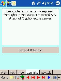
The first and second tabs are used to enter plot data; the second tab is used to enter tree data; the fourth is used to review, navigate and perform some basic calculations based on the plot data collected so far. The fifth and final tab is for entering additional remarks about the plot not covered in the other tabs. This is the basic configuration. If no navigation or set up configurations are needed, filling in is all that is needed to perform and record mensurations and calculations in a forest inventory plot.
Data creation and entry in the five tabs can be controlled with the icons. Because most of the time the person entering the data is not the forester her/himself but an aide, usually a villager or local with little experience with computing, all of the main data entry functions can be performed with only eight icons. The menu is intended for the forester to handle.

The first icon opens a window for browsing through and accessing available plots, if they have been previously controlled or entered into the device, for instance, to perform re-mensurations as is usual in growth monitoring inventories or in temporal plots when the measurements have not been finished the previous day.
To create a new plot, after filling in the data on the first and second tabs, the second button creates a new file for the sector, if it is was not previously created in the device, and a table in the file for plot data, in which a row is generated to accommodate plot attributes. If the file for the sector already exists, only an additional row for the new plot is created.
Once a plot is opened or created, the third icon in the shape of a tree allows entering tree data into the plot database after filling in the third tab. These data are recorded as per-tree rows in an additional table in the database.
The red icons are used for navigating between trees that have been entered, setting the program in “edit” mode. If data are changed, they are saved through the “tree” icon. The blue and last icon is used to navigate between trees “flagged” for height, since the standard procedure is usually to measure all DBHs in the plot first, and then measure some tree heights last. During the tree diameter mensuration processes, some trees can be chosen and flagged for later mensuration, with the blue checkbox near the DBH box.
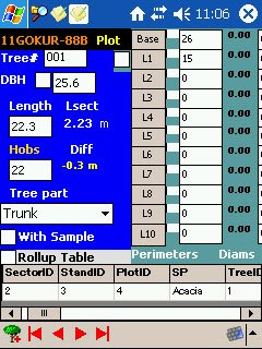
Control arrangement in the third tab of the Digi-Tally is dynamic and can change depending on the instruments selected on the first tab. For instance, as shown in Figure X, when the user chooses to measure the plot with a metric tape instead of diameter tape, and uses a VERTEX height meter for measuring tree height, the Scale Field has no purpose and is replaced by an Angle Field. The DBH field is also replaced by a GBH (Girth at Breast Height) field. In some occasions when DBH has to be measured at two spots for averaging, when there is a lump or something else that would hamper measurements at breast height, the red checkbox next to DBH or GBH invokes the double diameter fields.
Besides the basic icons and tabs, more functions can be accessed with the menu. Once the first and second tabs have been filled, the menu can be accessed for choosing plot setup options and other modules.

Plot establishment module

This lets the user choose among circular or rectangular plot setting modes. The Circular Plot option provides the user with the calculation of the plot radius compensated for terrain slope; the Rectangular Plot (Figure X) provides the user with a sub module in which the necessary calculations for correctly setting up a plot of the desired dimensions can be performed, such as area, angular and closure errors and precision estimation, among others. A sketch of the plot is also provided.

Materials and Methods

Data collected in the field

Data collected in the field in forest inventory operations can be divided in two broad categories:
1) Plot Data
- PERSON(S) WHO MAKES THE MEASUREMENTS.
- INSTRUMENTS USED.
- LOCATION OF THE PLOT. Sector ID, Stand ID, and geographic coordinates, as well as the datum or type and data of the cartography or aerial photographs used to locate the plot in the field.
- UNIQUE IDENTIFICATION FOR THE PLOT (A NUMBER OR CODE). Consecutive numbers are desirable.
- SPECIES OF TREES IN THE PLOT.
- TYPE OF PLOT AND CHARACTERISTICS OF PLOT SET-UP. Dimensions, area, shape of the sampling unit, number of sub-compartments.
- OBSERVABLE FEATURES OF THE SITE. Altitude, slope amount and type, soil type, drainage conditions, characteristics and composition of undergrowth, aspect (general orientation of the slope regarding north, south, etc.), general remarks on the health and condition of the stand and signs of the presence of possible pests, evaluating how widespread they seem to be.
2) Tree data
- SECTOR, STAND AND PLOT TO WHICH THE TREE BELONGS.
- TREE SPECIES. In the case of multiple species plantations or natural, non-homogeneous stands, it must be possible to record tree species for each individual.
- NUMERICAL ATTRIBUTES MEASURED. DBH, tree height and the measurements used to calculate it, crown diameter or radii. In the case of log scaling, length of the tree trunk, diameters and bark thickness at stump height as well as at each 1/10th of tree length; weight and part of the tree from where samples were taken, if they were, should also be recorded.
- QUALITATIVE ATTRIBUTES MEASURED. Crown position, stem or crown defects, diseases or otherwise abnormal or undesirable conditions observed on each individual tree; height to which DBH was measured and additional remarks, if needed. In the case of log scaling, parts of the tree measured; note if samples were taken or not.
The Digi-Tally was developed to cover field data collecting and digitizing of both plot and tree data in real time while in the field.

Log scaling module


This can be invoked from the menu for plotless log scaling, or from the review tab for selected trees in a plot. After the tree is felled and its length is measured, mensurations of stem diameters, along with bark thickness along the tree trunk in increments of 1/10th of tree stem length can be recorded.

Structure of the System

The system was developed in Microsoft Visual.NET Compact Framework 2003 development environment for the Pocket PC handheld platform so it can be easily ported to a full desktop version like tablet PCs and such. It comprises an interface of five tabs, a menu and eight toolbar icons. The Digi-Tally can be configured to work in English, Japanese, Spanish, French, and Brazilian Portuguese, as shown. Options for German, Chinese and an additional language are also presented. The system currently has no German or Chinese interface; however, instructions to translate the program to any language are presented in the system’s manual. Options to change among unit systems, as well as between screen orientations to match the device or settings fitting the user needs are also present in the Settings menu.